


Product classification

Lixel L2 Pro Handheld Laser Scanner | Flagship Real-time Scanning and Modeling Device
Retail Price
Market price
Weight
Stock surplus
0
隐藏域元素占位
- Product Description
-
- Commodity name: Lixel L2 Pro Handheld Laser Scanner | Flagship Real-time Scanning and Modeling Device
The Lingguang Lixel L2 Pro handheld laser scanner, deeply integrated with multi-source perception modules and combined with AI intelligence, leads SLAM devices into the "0 Processing Era," bringing point cloud data comparable to the post-processing quality of previous models.
1. Product Overview
The Lingguang Lixel L2 Pro handheld laser scanner, as a flagship real-time scanning modeling device, deeply integrates multi-source perception modules, combined with AI intelligence, leading SLAM devices into the "0 processing era", bringing point cloud data comparable to the post-processing quality of previous models.
2. Product Features
(1) Integrated and deeply optimized
Rotating laser radar: High-precision scanning, accurately capturing spatial information.48 million ×2 pixel panoramic vision: Eliminating the need for external cameras, panoramic vision coverage, scanning without dead angles.Ultra-high precision 6DOF IMU: High-precision posture measurement, ensuring the accuracy and stability of scanning data.Multi-SLAM joint optimization: Releasing hardware performance, efficient data processing and modeling.(2) Real-time output, true SLAM
Instant positioning and mapping: The core of SLAM technology, real-time output of point cloud data, accuracy reaching L2 post-processing effect, no waiting required.Real-time coloring effect: Presenting realistic colored point clouds, providing intuitive data for subsequent modeling analysis.

L2 Pro real-time
Real-time absolute coordinate point cloud
(3) Exclusive algorithm, ultimate point cloud
High-density point cloud: 1 million points /㎡, 1mm spacing, capturing every detail.Thin point cloud thickness: Only 5mm, accurate drawing and line drawing, improving modeling accuracy.Ultra-high coloring accuracy: Photo-level colored point cloud, high color restoration.
(4) Powerful SLAM, deep into complex sites
Self-developed Multi-Slam algorithm: Enhancing scene adaptability and reliability, can continuously obtain absolute coordinates in areas lacking satellite signals such as indoors and underground.Real-time absolute coordinate point cloud: Providing accurate spatial positioning information for complex site scanning and modeling.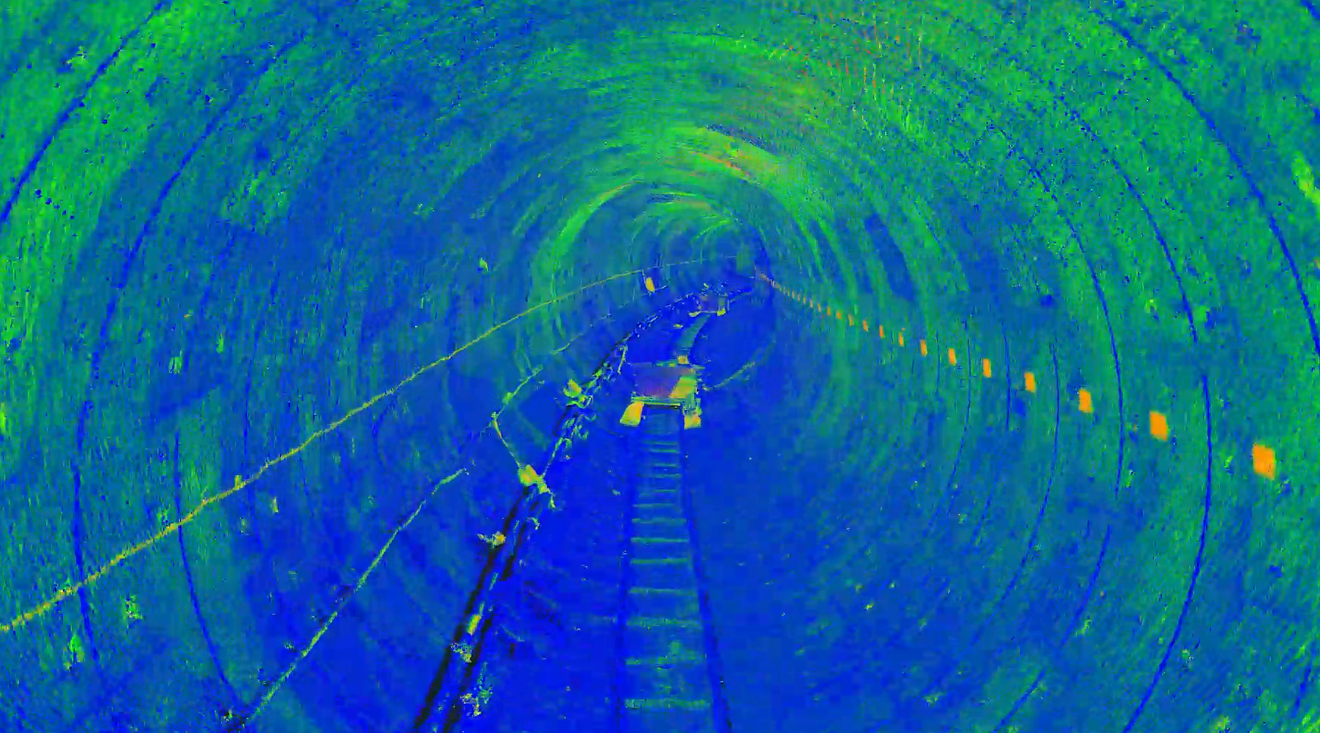
Friendly and reliable new operating experience
3. Software Support
(1) Lingguang Lixel supporting APP
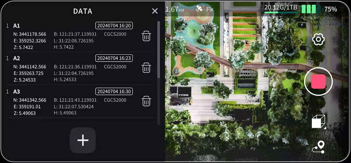
- Full-process scanning operation : Supports RTK point marking, breakpoint continuation scanning and other functions to meet different operational needs.
- Real-time data viewing : Real-time viewing of camera images, elevation, and true color point clouds, ensuring the accuracy of data collection.
- Device status monitoring : Fully displays rich information such as battery, network, memory, measurement range, and collection status, allowing users to grasp device status at any time.
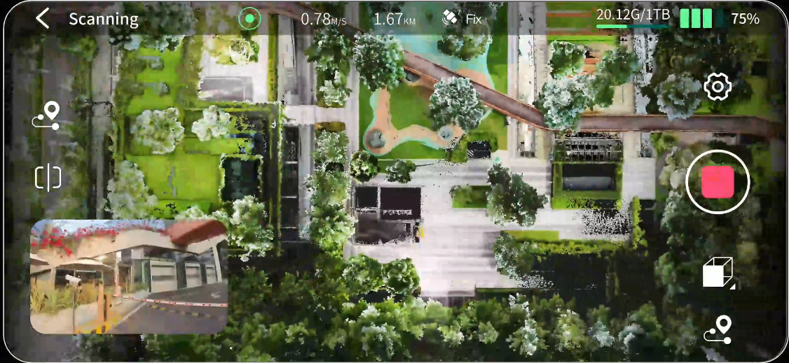
One screen control, one-click operation
(2) LixelStudio one-stop point cloud processing software (optional)
LixelStudiois a one-stop 3D point cloud processing software based on spatial intelligent algorithms, providing viewing, editing, processing of point cloud data and industry plugins, throughAIcapabilities to enhance data processing quality and efficiency, bringing breakthrough 3D data productivity.
*One-click project processing
One-click processing of point cloud data, improving point cloud accuracy and expressiveness.
L2 ProExclusive point cloud enhancement, improving point cloud density, uniformity, and color attachment effects.
*Map fusion
Fusion processing of multiple batches of data to obtain complete large scene point cloud data.
*Cloud map overlay
Cloud map overlay, point cloud data overlaid with panoramic images for convenient mapping and measurement.
*Processing and editing
Point cloud registration, denoising, length and area measurement,3Dcropping and other rich tools.
*Rich rendering
RGB, intensity, elevation,EDL, and various rendering modes.
*Accuracy report
Verify point cloud accuracy manually or automatically, and generate accuracy reports.
*Industry applications
Volume measurement comparison,Mesh,5Gtransmission and other industry functions will be launched successively.
4. Technical Parameters
Overall parameters
Handheld device weight
1.7kg(Excluding battery)
Data Interface
USB3.1 Gen2
Handheld Size
180mm×130mm×400mm
Storage Capacity
1T SSD
Shell Material
Aluminum Alloy
Continuous Scanning Time
1.5h
Power Consumption
<30W
Wireless Module
Supportwifi, Bluetooth:
802.11a/b/g/n/ac,
2.4G Wifi 2412-2472MHz
5G2 Wifi 5180-5240MHz
5G8 Wifi 5745-5825MHz
Working Environment
Working Temperature
-20°C~50°C
Protection Level
IP54
Special Features
Visual Assisted Positioning
Support
Real-timeRTKFusion
Support
Real-time True Color Point Cloud
Support
Output Format
Point Cloud Format
.las
Image Format
.jpg
Real-time Accuracy
Absolute Accuracy Elevation (RMSE)[2]
3cm
Relative Accuracy (RMSE)[3]
2cm
Absolute Accuracy Plane (RMSE)[2]
3cm
Post-processing Accuracy
Absolute Accuracy Elevation (RMSE)[4]
3cm
Point Cloud Thickness[6]
0.5cm
Absolute Accuracy Plane (RMSE)[4]
3cm
Horizontal Accuracy(RTKFusion)
0.015°
Relative Accuracy (RMSE)[3]
1cm
Horizontal Accuracy (NoRTKFusion)
0.03°
Repeatability Accuracy (RMSE)[5]
2cm
Point Cloud Enhancement
Support
Laser
Working Range
0.5m~120m
0.5m~300m
Scanning Data Rate
320,000 points/s
640,000 points/s
Laser
Class 1/905nm
Laser Field of View
360°×270°
Panoramic Camera
Resolution
2×48MP
CMOS Size
1/2”
Focal Length
2mm
Shutter Type
Rolling Shutter
Aperture
F/2.0
FOV
190°×190°
Panoramic Image Resolution
Up to 56MP
Emergency rescue
Criminal technology
| More Products

")


| Product Messages
Get in touch with our team in a timely manner and be happy You offer help
* Note: Please be sure to fill in the information accurately and keep the communication unblocked. We will get in touch with you as soon as possible.
Contact Us
Service Hotline
Telephone:020-83513401
Fax:020-83513401
After sales:400-613-1580
E-mail:sales@tyntec.cc
Website:www.tyen-ai.cn
Address: Room 3012, No. 316 Huanshi Middle Road, Yuexiu District, Guangzhou,Guangdong,China
Zip Code: 510095


WeChat Official Account
Links:
©2024 Guangzhou Tyen Electronic Technology Co., Ltd SEO